Digital Humanities
DH2010
King's College London, 3rd - 6th July 2010
An Open Source Toolkit for Flexible Browsing of Historical Maps on the Web
See Abstract in PDF, XML, or in the Programme
Ohno, Shin
Ritsumeikan University
ohnoshin@gmail.com
Saito, Shinya
Ritsumeikan University
Inaba, Mitsuyuki
Ritsumeikan University
Map browsing on the web is now commonly used, and most people have used map services such as Goole Maps, Google Earth, and Yahoo! Maps. These services also provide developer API, which makes it easy to integrate map services into the website. Map browsing in practical use is covered with those services, but displaying historical maps as exhibits is not, which requires different approaches.
We, three members of Web Technology Research Group of the Digital Humanities Center of Japanese Arts and Cultures, Ritsumeikan University have developed an image viewer, which can handle zooming, panning, and rotating. Although there exist many similar toolkits, none has all three features with JavaScript written. Furthermore, we would like to share it as open source library.
This paper starts with elucidating Japanese historical maps, their unique features and needs. After that, it discusses our image viewer, its design and implementation to meet their needs.
Purpose
Since Japanese historical maps do not have concepts of geo-coding usually and are distorted, it is difficult to integrate them with map services such as Google Maps.
Using Keyhole Markup Language (KML) makes it possible to integrate these maps with Google Earth. There is some research on historical maps on Google Earth (Zeile et al. 2007Nishimura et al. 2007). Although those tools are highly functional for defining 3D geographical information on the web, the user interface is not easy to use for traditional humanities scholars who are normally not familiar with KML language. Moreover, setting the image in Google Earth is not always their priority. Therefore, when it is necessary to exhibit original, hand-drawn maps on the web, one has to take different approaches to integrating these images into the web.
Because of these issues, image viewers are usually used to implement historical maps for exhibition. These viewers enable users to zoom images, and to see their details if they are provided in high quality. Moreover, today’s high technology for user interface allows us to use such viewers with regular web browsers.
Since most of these viewers are not open source based applications, however, no room exists for us to extend and add more features. Even though they are provided as open source, most of them depend on a Flash plug-in, and there is no implementation with JavaScript. Because JavaScript is lightweight and easy to be integrated into websites, we have decided to implement this map viewer with JavaScript, and open it to the public as an open source product, and we believe there should be alternative options for us as open source based toolkits for these needs.
Design
-
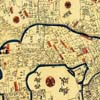
- Figure 1: Sample of Japanese historical map
In this section, we discuss what kinds of features are required for historical map viewers, and compare them with related software.
When displaying Japanese historical maps as image exhibits on the Web, we encounter difficulties in handling angles. With no clear concept of top or bottom in these maps, names of places are labeled from many directions. This is related to the fact that people in those days put rather a large map on the table or the floor to read it. Because of this particular feature of the historical maps, as opposed to maps today, browsing tools for these historical maps should provide a way of viewing them from multiple angles. Therefore, we decided to design our tool to support flexible browsing rather than geographical accuracy.
What we found out about other image viewers is that many can support zooming and panning, but not rotating. Most of them also depend on a Flash plug-in, and there are no implementations with JavaScript. There are comparisons of similar software for viewer of maps or images.
-
Google Maps/Google Earth: Since their beginning, these
services with web browsers have become more commonly used, and more
people have become used to them, which in turn has changed the way we
access geographical resources. However, historical maps do not have
accurate longitude and latitude, and even using KML to integrate them
into Google Earth, the images are distorted and we need to change the
purpose to display them. Plus, KML is rather complicated to maneuver it
very well.
API Free Rotatable Zoomable Image Cutting Open source Google Maps Yes Yes No Yes Yes No Google Image Cutter No Yes No Yes Yes Yes Google Earth Yes Yes Yes Yes Yes No Open Zoom No Yes No Yes Yes Yes Open Layers Yes Yes No Yes Yes Yes Ojikit Image Viewer No Yes Yes Yes No Yes - GMap Image Cutter by LCUGMap Image Cutter by LCU: : To use Google Maps image viewer, LCU developed GMap Image Cutter tool to cut a large image into many small pieces. With this Cutter provided, users can integrate images to their own website with the same Google Maps user interface.
- OpenZoom: : OpenZoom is a free and open source toolkit for delivering high-resolution images and zoomable user interfaces. Like GMap Image Cutter, it can cut a large image into many small file-size images. With this software, users can download an appropriate file size to their local computer, which works to prevent network traffic from congesting in cases in which the image is too large to download. This is SWF based, and requires a Flash Plugin.
- OpenLayers: : OpenLayers is a free and open source library for handling geographical information written in JavaScript. Since OpenLayers implements both WMS(Web Map Service) and Web Feature Service, users can integrate many different maps service to their own website. It has zooming and panning features for browsing maps on the web.
- Ojikit ImageViewer: Ojikit Image Viewer is the toolkit we have developed. It has zooming, panning, rotating features, as well as an open source license. While it does not have the function to cut a large image into smaller files, improvement of broadband allows us to transfer files without so much reduction. Moreover, one file is easier to store and manage than many files.
Implementation
Giving consideration to what historical maps viewers need to be, we have developed an open source toolkit. This toolkit is written in JavaScript, and it has lightweight features and an open source license. Written in JavaScript, Mozilla and Safari based browser uses SVG, and the Internet Explorer uses VML to handle vector images. To develop this library seamlessly in different browsers, this library depends on jQuery and Raphael.js.
Application
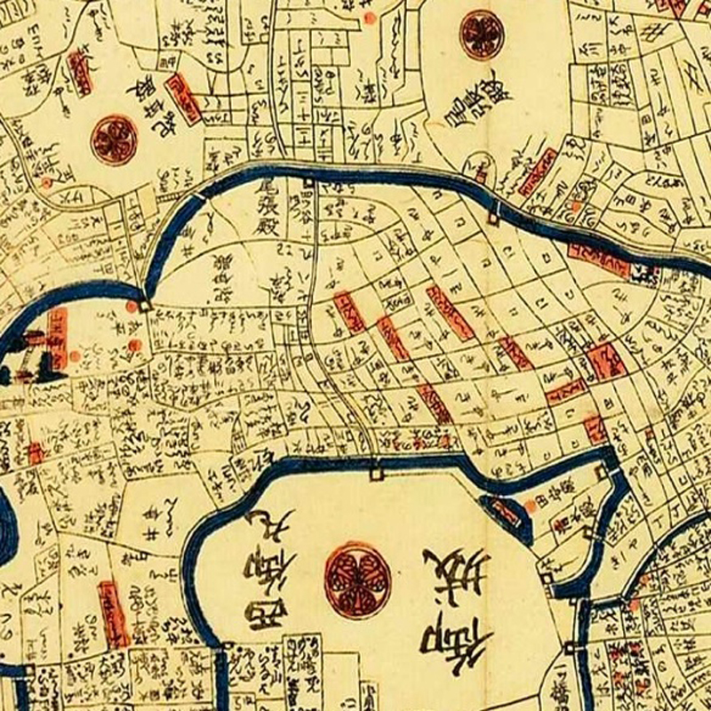
We have applied this tool to Japanese historical maps as our Center has a large number of historical map images, open to the public. Unlike other image viewers, which do not support rotating function, this toolkit enables us to rotate all images. Figure 2 shows one example of these map images as they look on the screen. With this toolkit, users can read labels written from many directions, as they are on the map.
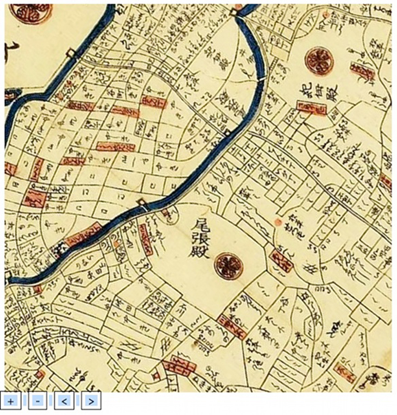
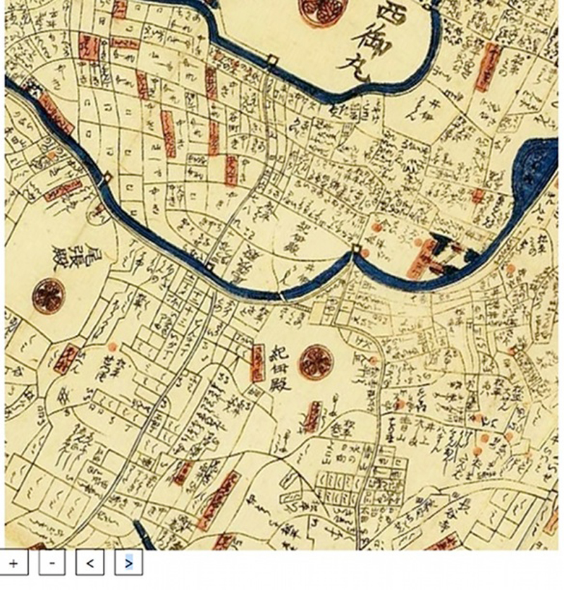
Figure 2: The left map is rotated 130 degrees, and the right map is rotated 210 degrees.
Conclusion
Addressing a culture-specific problem of Japanese historical maps, this paper discusses current map viewer systems to deal with this problem. This toolkit was developed as a viewer for Japanese historical maps per se. However, its extensive and easy integration feature leads us to consider some other possibility to apply it for other fields that have similar demands such as rotation and zooming features with easy integration. While this toolkit’s development is our on-going project, its source code is meanwhile open to any users.
There are three future areas of research related to our toolkit. First, we have applied our toolkit to Japanese old maps browsing as a test this time, and we are trying to produce more tests with the toolkit. Secondly, related to the first point, we think that this toolkit is useful not only for maps, but also for other images that need to be browsed from many different directions, such as handwriting manuscripts, and apply different resources. Finally, this toolkit does not consider geo-reference. In our center, there is a group for GIS research, and for future provision, we are discussing how to co-reference its geographical information with each other, so that this tool can represent geo-reference.
References
- Nishimura, Y. et al. (2007). 'Analysis of Silk Road Old Maps Using Google Earth'. SIG Computers and the Humanities Symposium 2007. Information Processing Society of Japan, pp. 155- 162
- Zeile, P., Farnoudi F. and Streich, B. (2007). 'Fascination google earth - use in urban and landscape design'. Embodying Virtual Architecture: The Third International Conference of the Arab Society for Computer Aided Architectural Design (ASCAAD 2007). Pp. 141-148
- Google Maps. http://code.google.com/intl/en/apis/maps/ (accessed 10 October, 2009)
- Google Earth. http://earth.google.com/intl/en/ (accessed 10 October, 2009)
- GMap Image Cutter. http://www.casa.ucl.ac.uk/software/googlemapimagecutter.asp (accessed 10 October, 2009)
- OpenZoom. http://openzoom.org/ (accessed 10 October, 2009)
- OpenLayers. http://openlayers.org/ (accessed 4 March, 2010)
© 2010 Centre for Computing in the Humanities
Last Updated: 30-06-2010