Digital Humanities
DH2010
King's College London, 3rd - 6th July 2010
"Inventing the Map:" from 19th-century Pedagogical Practice to 21st-century Geospatial Scholarship
See Abstract in PDF, XML, or in the Programme
Nowviskie, Bethany
Scholars' Lab, University of Virginia Library
bethany@virginia.edu
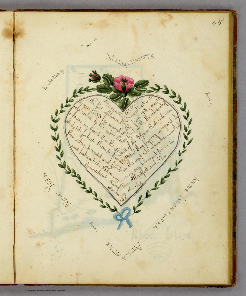
In 1823, at a small school in western Vermont, Frances Alsop Henshaw, the 14-year-old daughter of a prosperous merchant, produced a remarkable cartographic and textual artifact. Henshaw’s "Book of Penmanship Executed at the Middlebury Female Academy" is a slim volume, later bound in marble boards, containing – in addition to the expected, set copy-texts of a practice-book – a series of hand-drawn, delicately-colored maps of our nineteen United States, each one paired with an edited, geometrically-designed and embellished prose passage selected from the geography books available to a schoolgirl in the new American republic.1 Henshaw’s maps and texts alike are interpretive re-presentations of this body of contemporaneous geodetic and descriptive literature. Formally, many of the textual passages that accompany her maps are designed within a framework of aesthetically-inflected cardinal coordinates, representing (either conceptually or in their spatial contours) the states they describe, and positioning political and natural boundaries in cartographically appropriate margins of the page [see Figures 1 and 2].
As a work of juvenilia, Henshaw’s "Book of Penmanship" is no less remarkable in its artistic and imaginative accomplishment for being exemplary of larger trends in the geographic education of nineteenth-century Americans. A sampler in codex form, the book constitutes a set of interrelated pedagogical and personal exercises in geospatial and textual graphesis, or subjective knowledge-production through the creation of images and texts-as-image. Drawing exercises of this sort were developed by noted American educator Emma Willard, founder of Henshaw’s Vermont school and author of several geography textbooks. In a period when reading and recitation of geodetic texts were presumed the best aids to spatial memory, Emma Willard believed that students should learn through the personal creation and analysis of drawings – even, or perhaps especially, of drawings that embed subjectivity and aesthetic choice. ("In history," wrote Willard, with characteristic confidence, "I have invented the map.")2 My presentation argues that attention to the processes and products of Willard’s pedagogy can be as fruitful for modern scholars, who grapple with the integration of geospatial technologies into the interpretive humanities, as geographers and literary historians demonstrate them to have been for meaning-making among an increasingly spatially-literate populace in the early years of the American republic (See Brückner, 2006; Schulten, 2007).
Work and interest in the geospatial humanities is growing – at a variety of scales, and with a variety of institutional inflections – in libraries, academic departments, and digital centers around the world. Despite the richness of this activity, scholars press up against a well-documented series of obstacles, pragmatic and conceptual, in their use of spatial tools, datasets, and methods.3 In the ongoing interchange of the digital humanities, could new methods and self-consciously literary and ludic perspectives permit us, with Emma Willard, to invent the map?
An examination of spatial decision-making and of the interplay among text, image, and geographical source material in the Henshaw book may suggest relations among her enterprise and some ambitions held by modern humanities scholars for geospatial technology. These relations hinge on an openness to graphesis and iterative design as a legitimate method in digital scholarship. I will also argue that a fresh, steady look at cartographic and geospatial technologies for the digital humanities should not be taken alone in the context of spatially-oriented disciplines (such as anthropology, area studies, archaeology, and environmental history) that have more traditionally made use of these tools and datasets and have, to greater and lesser extents, made peace with their present limitations – a set of assumptions that underlie and circumscribe the analytical and expressive power of geospatial information systems (GIS). Instead, I want to extend our examination of GIS technologies and the administrative, pedagogical, and scholarly publishing systems that support them into the realm of interpretive literary and textual studies – and imagine them at a variety of scales: from support for a complex mapping of print-culture production and distribution networks through space and time; to the visualization of subjective spatial expression in historical and literary documents; to an examination of the spatial and typographical features of a single page, or class of page designs. What potential might geographical tools and methods have for illuminating the spatial, semantic, and intertextual features of books as well as landscapes? Can we imagine a next generation of these tools in support of visual and aesthetic methodologies for very traditional (and, in some cases, only marginally geospatial) humanities interpretation?
If our aim is to promote, among colleagues in fields like literary studies and digital history, a new and timely engagement with geospatial visualization as interpretive practice (timely both in terms of the burgeoning development and use of what have been called "vernacular" or crowd-sourced spatial datasets and interfaces outside of the academy, and in the context of a growing interest in a return to pragmatic, methodological training in graduate education within it),4 we must ask the following question: what is required of our shared tools, methods, and pedagogical practices to allow us to make as meaningful a visual intervention in our current scene as Emma Willard did in hers?
The deficiencies of existing geospatial applications and the social and academic systems that support and promote their use have been adequately surveyed. Martyn Jessop provides a thorough summary in the pages of LLC, when he identifies four factors contributing to a strange "inhibition" of the use of geospatial information among digital humanists, a community not generally daunted by the need to learn new software tools, metadata standards, and data curation practices (Jessop, M., 2008). The "first and most fundamental" of these inhibiting factors "concerns the use of data visualization and images per se in the discourse-based research methodology of the humanities" (42). That most humanities disciplines only make superficial use of images and image-based methodologies suggests an opportunity, if not a need, to interrogate our habitual interpretive practices and the ways in which graduate education perpetuates a longstanding marginalization of the visual – particularly infelicitous in light of the opportunities for production and analysis afforded by new media. Other factors involve: the suitability of current geospatial software packages to the treatment of issues like subjectivity and emotion, temporality as experienced and expressed in the documentary record, or interpretive inflection in the humanities; and those specific qualities of humanities information unsuited to tools that have been designed for synchronic analysis of incredibly dense datasets (rather than for sparse, temporally-inflected data) and with a scientific eye toward filtering out – rather than celebrating and analyzing – uncertainties or ambiguities. Finally, Jessop treats broader issues of scholarly communication: issues in funding, producing, evaluating, and distributing innovative geospatial scholarship in disciplines whose structures evolved in response to different conditions and expectations. With Jessop, I will suggest that, "although we usually think of GIS as a positivist tool its greatest contribution to the humanities… may be not as an analytical or information presentation tool but as a reflexive one," allowing us not only to engage with the "highly experiential" and qualitative features of our datasets, but also to reflect on how we construct our disciplines (46).
Frances Henshaw’s "Book of Penmanship" – a sophisticated, if naïve, 1820s pen-and-ink GIS – serves here as an example of both an illuminative process for, and a potential exemplar product of, a potential hermeneutic involvement on the part of scholars with textual surrogates and geospatial interfaces. We lack digital tools expressly crafted to promote the kind of ludic, iterative, graphical engagement with book design and geographical expression that is everywhere evident in the Henshaw cartifact. But the components of these tools are all around us. It is less a technical than an institutional and intellectual problem to identify the small pieces – and practices – that must be loosely joined in order for humanities scholars to move forward in the arena of geographic and textual graphesis, or knowledge-making through graphical expression (Drucker, 2001; 2009).
Is there a methodological approach that presents itself as a way to crack open analytically – or perhaps just allow us to replicate and play in digital environments with – the easy brand of spatial and literary intertextuality evinced in Henshaw’s schoolgirl exercise? I will look at a several classes of tools and digital humanities practices as a way of getting at this question, including: the iterative, interpretive, and structured sketching prototyped in Temporal Modelling (Drucker, J.D. and Nowviskie, B., 2004) and Neatline;5 data-mining for geography in massive text corpora through tools like MONK and TAPoR, and what the Google Books research repositories and efforts like HATHItrust must enable in their APIs to contribute to this field;6 textual and graphical collation interfaces predicated on visualization rather than – or as much as – on structured markup, such as Juxta and Sappheos;7 mobile, GPS-powered tools and toys; and powerful, analytical GIS applications like the ESRI products, not at all designed for textual studies, but ready nonetheless for some dedicated gate-crashing.
-
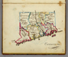
- Fig. 1: Connecticut, one of 19 maps in Frances Henshaw’s "Book of Penmanship Executed at the Middlebury Female Academy," 29 April 1823. Library of David Rumsey.

-

- Fig. 2: Descriptive and positional text accompanying the Connecticut map; Frances Henshaw, 1823. Library of David Rumsey..
References
- Brückner, Martin. (2006). The Geographic Revolution in Early America: Maps, Literacy, and National Identity. University of North Carolina Press
- Drucker, Johanna (2009). SpecLab: Digital Aesthetics and Projects in Speculative Computing. MIT Press
- Drucker, J.D. and Nowviskie, B. (2004). 'Speculative Computing: Temporal Modelling'. A Companion to Digital Humanities. Susan Schreibman and Ray Siemens (ed.). Oxford: Blackwell, pp. 431-447
- Drucker, Johanna (2001). 'Digital Ontologies: The Ideality of Form in/and Code Storage—or— Can Graphesis Challenge Mathesis?'. Leonardo. 34:2
- Jessop, Martyn (2008). 'The Inhibition of Geospatial Information in the Digital Humanities'. Literary and Linguistic Computing. 23:1
- Ramsay, Stephen (2005). 'In Praise of Pattern'. TEXT Technology: the journal of computer text processing. Volume 14, Number 2
- Schulten, Susan (2007). 'Emma Willard and the graphic foundations of American history'. Journal of Historical Geography. 33: 542-564
Footnotes
- 1.
- Accession #2501 in the Rumsey collection: http://davidrumsey.com/ Back to context...
- 2.
- Emma Willard to "Miss Foster," 5 November 1848. Reprinted in Lord’s Life of Emma Willard. New York: 1873; page 228. Back to context...
- 3.
- See the executive summary and report of the 7th annual Scholarly Communication Institute, Charlottesville, VA, 2009. SCI 7 focused on "Spatial Technologies and the Humanities:" http://uvasci.org/ and http://uvasci.digress.it/ Back to context...
- 4.
- “Vernacular” is perhaps a poor term to address commercial, cloud-based, and “neo-geo” tools and interfaces based on mobile technologies, GPS, virtual globes, and Web-based slippy maps. See Scholarly Communication Institute 7 report on “vernacular” technologies & reports from SCI 6 and 7 on methodological training: http://uvasci.org/ Back to context...
- 5.
- Neatline is a tool for the creation of interlinked timelines and maps as interpretive expressions of the literary or historical content of archival collections, currently under development by the Scholars’ Lab at the University of Virginia with generous funding by the NEH: http://neatline.org/ Back to context...
- 6.
- In this area of activity, see Stephen Ramsay (2005) on "computational analysis in literary studies as a quest for interpretations inspired by pattern," which can move the "hermeneutical justification of the activity away from the denotative realm of science and toward the more broadly rhetorical and exegetical practices of the humanities." Back to context...
- 7.
- See http://juxtasoftware.org and http://sapheos.org/ Back to context...
© 2010 Centre for Computing in the Humanities
Last Updated: 30-06-2010