Digital Humanities
DH2010
King's College London, 3rd - 6th July 2010
Unfolding History with the Help of the GIS Technology: a Scholar-Librarian Quest for Creating Digital Collections
See Abstract in PDF, XML, or in the Programme
Smith, Natasha
University of North Carolina at Chapel Hill
nsmith@email.unc.edu
Allen, Robert
University of North Carolina at Chapel Hill
rallen@email.unc.edu
Whisnant, Anne
University of North Carolina at Chapel Hill
anne_whisnant@unc.edu
Eckhardt, Kevin
University of North Carolina at Chapel Hill
kevineck@email.unc.edu
Moore, Elise
University of North Carolina at Chapel Hill
elimoore@email.unc.edu
Carolina Digital Library and Archives (CDLA) and Documenting the American South (DocSouth) are a digital library laboratory that creates, develops, and maintains online collections regarding the history of the American South with materials drawn primarily from the outstanding archival holdings of the UNC library. In this presentation, we plan to demonstrate how the close partnership between UNC librarians and faculty forges its path in the frontier of digital humanities. Our experience clearly demonstrates that digital historical scholarship cannot be done on the old model of the scholar laboring alone, “the solitary scholar who churns out articles and books behind the closed door of his office” (see Kenneth Price, 2008). By bringing together faculty and librarians’ expertise, collaborators endeavor to use digital technologies in a variety of innovative ways to collect, organize, and display data and materials that illuminate the temporal and spatial unfolding of historic events. Recent experimental work with GIS helps us to better understand how the use of digital technologies changes the way we do research in humanities and how it facilitates learning in the classroom. Indeed, “GIS, in combination with other branches of scholarship, has the potential to provide a more integrated understanding of history” (see Ian N. Gregory, 2003).
At the same time, the wide array of issues (digitizing and geo-referencing of Sanborn and other historic maps, use of JavaScript mapping APIs, such as Google Maps and the open-source Open Layers, for zooming and hotspot addition, layering and geo-tagging scholarly content) will be presented based on several completed and in progress digital history collections built in close collaboration of UNC librarians working with UNC scholars.
1. “Going to the Show” (www.docsouth.unc.edu/gtts/) is the first digital archive devoted to the early experience of cinema across an entire state. In a research project, Prof. Allen collaborated with digital publishing experts and special collections librarians at UNC to create an online, interactive digital collection of maps, photos, postcards, newspaper clippings, architectural drawings, city directories and historical commentary that illuminate and reconstruct cultural and social life during the first three decades of the 20th century in North Carolina. Supported by a grant from the N.C. State Library and a National Endowment for the Humanities Digital Humanities Fellowship, “Going to the Show” (GttS) developed the innovative system for layering content on electronically stitched and geo-referenced Sanborn Fire Insurance Maps. Especially in its highly detailed case study of early moviegoing in Wilmington, N.C., GttS demonstrates the extraordinary potential for illuminating community history through the interaction of documentary material and Sanborn maps (see Figure 1).
-
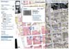
- Figure 1. Google Maps AP1 used to present 1915 SAnborn map with layered historic materials to document the moviegoing in North Carolina.
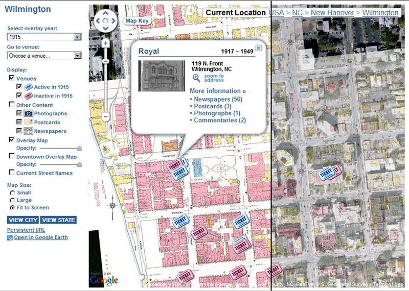
2. Building on the digital history project “Going to the Show”, the project team decided to expand the reach of their expertise by creating a web-based toolkit that will allow libraries, schools, museums, local history societies, and other community organizations to preserve, document, interpret, display, and share the history of their downtowns. Called “Main Street, Carolina: Recovering the History of Downtown Across North Carolina,” the toolkit will provide users with a flexible, user-friendly digital platform on which they can add a wide variety of “local” data: historical and contemporary photographs, postcards, newspaper ads and articles, architectural drawings, historical commentary, family papers, and excerpts from oral history interviews—all keyed to and layered on top of digitized Sanborn Fire Insurance Maps. The toolkit will consist of a PHP-based web application and a JavaScript API. The web application will be compact in size, resource-light, and easy to install on the local organization’s own web server or that of a third-party web-hosting service. It will provide administrative tools for configuring the site, creating place markers, creating simple web pages for content, and customizing the look and feel (see Figure 2). These place markers can then be associated with images, stories, or other content, providing a visual link between the content and related physical locations. The map interface is the focal point of the software and will allow users to explore content associated with specific geographic locations by interacting with place markers, or "push-pins," overlaid on top of historic maps. Clicking on a place marker's icon will display an information bubble which can contain text, images, and links to additional content. The user will be able to view and effortlessly pan across entire downtowns as a seamless integration of multiple high-resolution map pages; zoom from a bird-eye view to the smallest cartographic feature; compare successive map iterations showing the same building, block, or neighborhood; and overlay any of these views with contemporary satellite and map images at the same scale. The JavaScript API will allow users to include digitized maps created for other CDLA projects as layers in their own websites or mash-ups which use the Google Maps or Open Layers mapping APIs. For example, a user could embed an historic map in a blog post or add a Sanborn Map as a layer to their existing website which uses Google Maps to show the location of homes that are listed on the National Register of Historical Places. MSC is funded by a private funding and an NEH Start-up Grant. Development for this project began in October 2009. We plan to release the toolkit and pilot projects developed in collaboration with external partners in summer 2010, prior to the start of the conference.
-

- Figure 2. “Main Street, Carolina: Recovering the History of Downtown Across North Carolina” tool kit. Administrative form for entering historical documents.
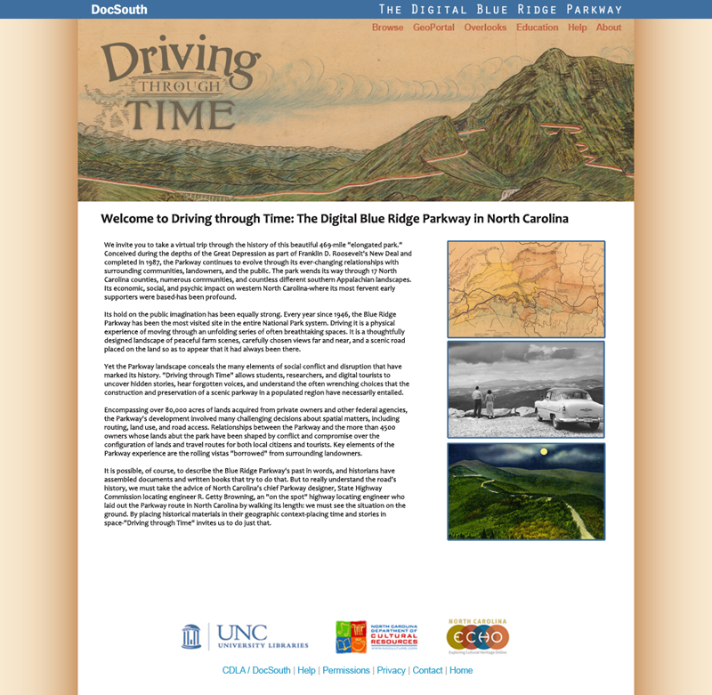
3. “Driving through Time: The Digital Blue Ridge Parkway in North Carolina” will present an innovative visually and spatially based model for illustrating North Carolina’s key role in creating the Parkway, representing the twentieth-century history of a seventeen-county section of the North Carolina mountains, and for understanding crucial elements of the development of the American National Park system. The project will feature historic maps, photographs, postcards, government documents, oral history interviews, and newspaper clippings. Each historic document will be assigned geographic coordinates so that it can be viewed on a map, enabling users to visualize and analyze the impact of the Blue Ridge Parkway on the people and landscape in western North Carolina over both space and time (See Figure 3). Primary sources will be drawn from the collections of the UNC-Chapel Hill University Library, the Blue Ridge Parkway Headquarters, and the North Carolina State Archives. These materials are especially significant in that they document one of North Carolina’s most popular tourist attractions, but also in the way that they help illuminate the way that the Blue Ridge Parkway transformed the communities through which it passed. In addition to the digitized primary sources, the project will include scholarly analyses of aspects of the development of the Blue Ridge Parkway.
A geospatial format is uniquely appropriate for considering the history of the Parkway and its region. As a narrow park corridor pushed through a long-populated southern Appalachian landscape, the Parkway rearranged spaces, repurposed lands, reorganized travel routes, and opened and closed economic opportunities through control of road routing, access, and use. The social conflicts it engendered, therefore, frequently entailed spatial components – should the road go here, or there; should it take more or less land; should this or that property be favored with direct Parkway access (or not)? Understanding these aspects of Parkway history without reference to spatial relationships on the land is challenging, as the project’s scholarly adviser, Dr. Anne Mitchell Whisnant, recognized when publishing her 2006 book, Super-Scenic Motorway: A Blue Ridge Parkway History (UNC Press). Her experience, both in writing the book and in delivering numerous public presentations since its appearance, is that narrative alone cannot provide the public with the tools to comprehend past controversies or present land protection challenges. Using digital and geospatial technologies to open a new window on the history of the Parkway and its region is especially timely considering the approach of the Parkway’s 75th anniversary in 2010 and the National Park Service’s 100th anniversary in 2016.
-
- Figure 3. "Driving throug Time: The Digital Blue Ridge Parkway in North Carolina"
The collaboration between the library and Dr. Whisnant has been enhanced by Whisnant’s engagement in related field of “public history,” which is history practiced outside the walls of academia, with and for public audiences. Based in academia but designed for public benefit, “Driving through Time” has offered an exceptional opportunity for involving undergraduate and graduate students in Dr. Whisnant’s Introduction to Public History class in its creation. As a scholarly project being built through the expertise of a large team (as nearly all public history undertakings are), “Driving through Time” has been an ideal space for students to gain hands-on experience in doing public history collaboratively, in real-time, with their instructor. Students are doing original primary source research in the university’s special collections, identifying materials for inclusion in the online exhibit, developing their own historical narratives, working with new tools such as wikis and databases, and contributing to the creation of metadata. Because the instructor has not predetermined the final outcome, furthermore, students are being given ownership over both their process and their final products and practicing navigating the unexpected twists, turns, delights, and disappointments that historical research always entails.
References
- Knowles, Anne Kelly (2008). Placing History: How Maps, Spatial Data, and GIS Are Changing Historical Scholarship. Redlands, Calif.: ESRI Press
- Whisnant, Anne Mitchell (2006). Super-Scenic Motorway: A Blue Ridge Parkway History. UNC Press
- Gregory, Ian N. (2003). A place in History: A Guide to Using GIS in Historical Research. 2nd Edition. http://www.ccsr.ac.uk/methods/publications/ig-gis.pdf
- Price, Kenneth (2008). 'Electronic Scholarly Editions'. A Companion to Digital Literary Studies. Schreibman, Susan and Siemens, Ray (eds.). Oxford: Blackwell
© 2010 Centre for Computing in the Humanities
Last Updated: 30-06-2010